Listen to audio version of this blog post:
LuxCarta can automatically extract building footprints from satellite images over vast areas. Learn more about how our solution works and the story behind our innovations.
At a glance:
- Extracting building footprints from satellite images was traditionally slow and manual.
- Our AI-driven process accelerates building footprint extraction significantly.
- Discover the benefits of our solution for your projects.
- Explore our 25-year journey to automatic building footprint extraction.
For many years, companies have utilized building footprints in their GIS tools to better understand towns and cities, enabling detailed project planning. However, extracting these footprints from satellite images has traditionally been labour-intensive, time-consuming, and manual. Identifying and separating individual structures from their surroundings required skilled professionals to spend countless hours on each image. Scaling this process to cover entire cities or countries demands enormous amounts of time and resources.
LuxCarta’s 3D building footprint extraction algorithm
Our AI-driven system automates the identification of buildings in satellite images. Trained on hundreds of thousands of images, it boasts over 95% accuracy in recognizing buildings. The system extracts individual buildings and converts them into vector or raster layers, and can also generate 3D models of these footprints.
Traditionally, building footprint extraction required large teams of trained workers to manually identify and extract building polygons from images. Scaling this up to regional or national levels could take months or even years, often delaying projects due to a lack of skilled staff and outdated images. In contrast, LuxCarta’s AI-driven process can produce maps for entire countries in just a few weeks, depending on the size.
Customers specify their desired city, region, or country, and we deliver quality-assured maps with building footprints promptly.
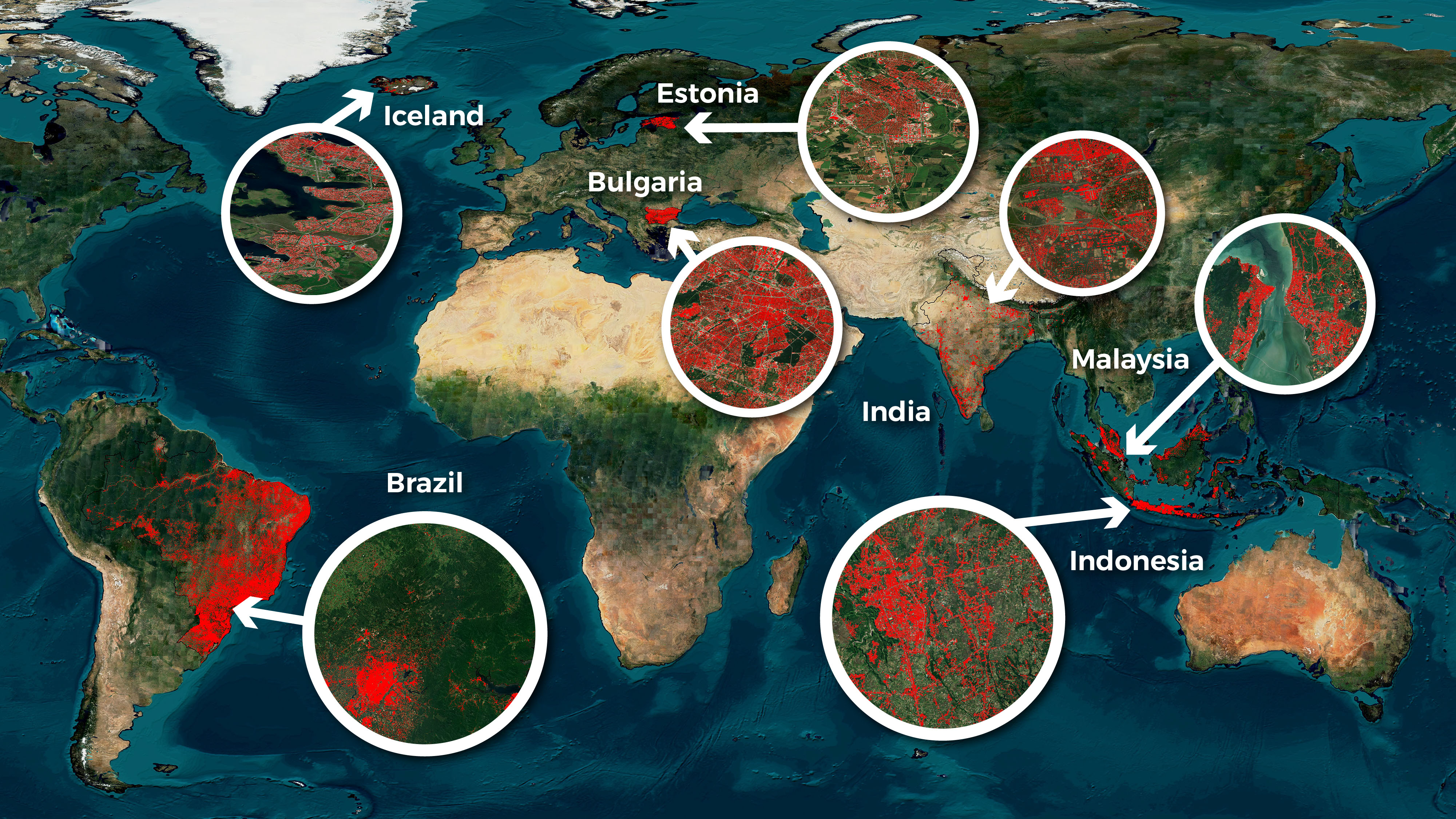
Building footprint extraction around the world with LuxCarta
Our AI-powered approach to building footprint extraction has already been used on several major projects:
- Brazil: We successfully mapped over 140 million individual building polygons nationwide and provided detailed 3D models supporting various applications.
- India and Malaysia: Similar efforts have resulted in extensive 3D building footprints, aiding urban planning and infrastructure development.
- Individual towns and cities: Our building footprint extraction process has been applied at the town and city scale in dozens of municipalities worldwide.
Why do organizations need 3D building footprints at scale?
There is growing interest in using 3D building footprints across multiple sectors, including telecommunications, government, mining, engineering, architecture, and urban planning. The benefits of using 3D building footprints at scale include:
- Makes RF Planning More Efficient: Comprehensive 3D building footprints allow for precise network planning, ensuring optimal coverage and performance.
- Faster Implementation: Our AI-driven process significantly reduces the time needed to produce detailed maps, enabling quicker decision-making and deployment.
- See the 'Bigger Picture': Instead of focusing on isolated sections, our maps provide a comprehensive view connecting various regions, enhancing strategic planning.
- Consistent View for Project Managers: Uniform data across entire regions ensures consistency, reducing discrepancies and improving project coordination.
- Cost Savings: Investing in a single, detailed map eliminates the need for multiple, less comprehensive maps, saving time and money.
Learn more: The need for 3D reconstruction from satellite images
3D building footprint maps for multiple industries
LuxCarta's 3D building footprint solutions support multiple industries:
- Telecommunications: RF planners can identify obstacles and place base stations and cell towers in optimal locations.
- Urban planning: Detailed 3D models assist in designing sustainable cities and optimizing land use.
- Training and Simulation: Companies can create ‘digital twins’ of the real world.
Our story: Pioneering AI in geospatial data
LuxCarta’s strength lies in its ability to accurately extract 3D building footprints at scale, a capability built on decades of refinement. Formed from the merger of ComputaMaps and Geoimage in 2007, LuxCarta has been a leader in global mapping for over 25 years. Initially focused on providing terrain maps for telecommunications during the GSM era, the company has continually evolved to meet the increasing demands of higher-generation technologies, from 2G to 5G.
Pioneering AI in Geospatial Data
Artificial intelligence (AI) has been central to our approach for many years. Our extensive geospatial data archive has trained our AI models, enabling us to undertake the colossal challenge of mapping entire countries in 3D. By leveraging machine learning algorithms and large datasets, we automate the extraction and analysis of geospatial features, reducing the time and effort required for manual processing. This has allowed us to produce highly detailed maps with unparalleled accuracy and speed. Our AI models are continuously refined and updated, ensuring we stay ahead of the curve in delivering cutting-edge mapping solutions.
The Future of 3D Building Footprint Maps
LuxCarta remains dedicated to supporting our clients with sophisticated mapping solutions as we continue to innovate and expand our capabilities. Our history of excellence and forward-thinking approach positions us as leaders in the geospatial sector, ready to tackle future challenges.
Do you require 3D building footprint maps for your next project? LuxCarta can deliver GIS maps at any scale - from small towns to major cities to national or global-scale projects.
Contact us today to learn more.
