Listen to audio version of this blog post:
We have developed a new process for automatic road network extraction from satellite imagery. If you need the most up-to-date view of road networks, our method is a significant improvement on established processes.
Key takeaways:
- We have developed a new fully automatic road mapping process from satellite imagery
- It’s more accurate, complete, optimized, and up-to-date than OpenStreetMap and other methods
- Learn how the process works
- Learn about results from recent tests
What would it mean for your organization if you could automatically extract road networks from a satellite image? If, at the click of a button, you could generate up-to-date maps showing the location of all kinds of roads and their connections at junctions?
Automatic road network extraction from satellite imagery has long been a major ambition for the mapping industry. In June 2024, the team behind BrightEarth published a paper describing our new method that uses deep learning for road detection.
We believe this is a significant step forward for satellite imagery road mapping. Learn more about the process, and how it benefits you.
The need for more accurate road networks in GIS
When they are mapping out roads, most organizations that use advanced GIS applications today rely on open-source inputs. Most often, they use solutions like OpenStreetMap (OSM). OSM is updated by volunteers who identify road networks (among many other features) and their location.
As valuable as these sources are, they have certain drawbacks:
- May go out of date: New road networks can grow quickly - especially in towns or cities that are developing fast. OSM can therefore quickly go out of date.
- Not always reliable: OSM and similar databases are updated and maintained by volunteers. While normally correct, accuracy is not 100% guaranteed.
- Not global: Relying on OSM and similar open-source initiatives means road network coverage may be patchy in areas where there are fewer people engaged in open-source map maintenance.
- Incomplete or broken connections: Many existing methods for automatic road network extraction from satellite imagery struggle to represent complete road networks. Often, connections at junctions or roundabouts are missing or incomplete.
A new method for automatic road network extraction from satellite imagery
The team behind BrightEarth has developed a new method that uses deep learning for road detection. Rather than relying on open-source data when you create maps, our technique uses the latest satellite image of a place of interest as the input. We then apply an AI process we developed that automatically identifies all roads from the image, and extracts entire networks as a vector for use in a GIS map.
The three-step process is as follows:
- Road segmentation
We have developed a neural network that identifies road interior and road contour. When part of the road isn’t visible (e.g. because a tree or building occludes it), the system is trained to smooth loss.
- Road network reconstruction
After roads are segmented, our process reconstructs the network and turns this into a vector. The process cleans clutter and ‘noise’ from the network, creates a skeleton of the network, and identifies the optimal location of connections between roads through graph optimization..
- Road material classification
A final stage in our satellite imagery road mapping process is to identify the road surface. Our process classifies roads into either processed (i.e. ‘man-made’ materials like concrete, tarmac etc.) or unprocessed (i.e. sand, dirt, gravel, etc.). This assessment is also informed by our Land Use Land Cover layer - if the surrounding landscape is mainly sand, then we estimate an unprocessed road is also made of sand.
Once this process is complete, a vector layer is made available to download for use in advanced GIS applications.
Results from our testing
To verify the accuracy of our new process for satellite imagery road mapping, we conducted three experiments in cities around the world with very different kinds of road networks: Timbuktu, Amman, and Aden.
We selected satellite images of areas in the three cities, and then our human experts carried out a manual road classification process, identifying all roads in the image.
Then, we applied our automatic road network extraction process. When compared to the manual approach, our results were very encouraging:
- Timbuktu: 94% accuracy
- Amman: 86% accuracy
- Aden: 87% accuracy
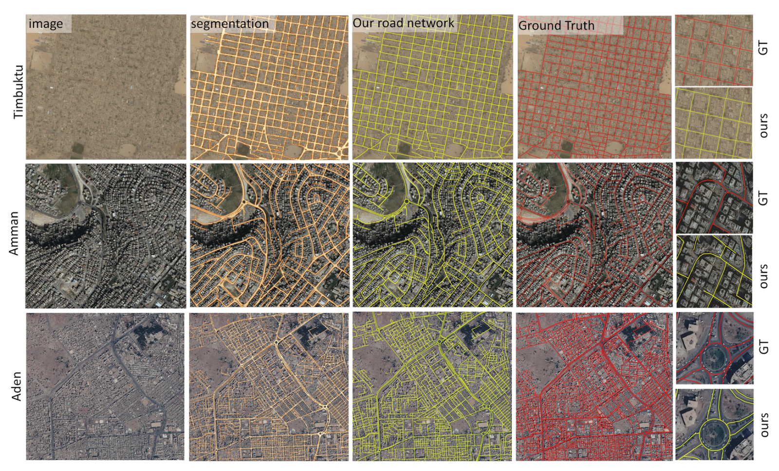
Image: Road networks generated by our pipeline over Timbuktu, Amman, and Aden (top to bottom rows), with input satellite images, road segmentation, our extracted road networks, the Ground Truth, and crops (left to right columns). In the crops, Ground Truths are marked in red and our results are in yellow.
What this data shows is that automatic road network extraction from satellite imagery can be almost as accurate as human extraction, while also being fast and reliable.
Who benefits from deep learning for road detection?
We believe our new satellite imagery road mapping process can make a real difference for a wide range of sectors.
- Simulation: Any organization that creates simulations for training purposes will benefit from using the most accurate, up-to-date representation of road networks.
- Logistics: Our process can help with route planning by showing the exact location of connections and junctions. It’s particularly helpful for logistics in places with unpaved roads - our technology can help logistics firms identify routes that are likely to be sandy, muddy or unstable.
- Urban planning: Urban planners can understand how cities are growing and prioritize the development of road infrastructure. By knowing which neighbourhoods are currently underserved (e.g. with sand roads rather than concrete), they can plan development more efficiently.
- Smart city technologies: Any company that installs remote sensors on roads and roadsides benefits from an accurate understanding of the exact location and material of road surfaces.
- National infrastructure planning: National road planning departments need the most up-to-date view of their existing road networks when planning development.
What’s next for BrightEarth road network mapping?
We believe our new method for automatic road network extraction from satellite imagery is a significant step forward. It will help multiple organizations that want to develop road networks, improve planning, and offer users better infrastructure. And we’re continually working to further enhance the process, with improved processes for complex scenarios (such as elevated bridges and intertwined elevated roads).
Interested in trying our AI-powered, satellite imagery road-mapping solution? Join BrightEarth’s Early Adopter Program, and experience it for yourself.
